
Topografische kaart Avoca
Interactieve kaart
Klik op de kaart om de hoogte weer te geven.
Over deze kaart
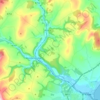
Naam: Topografische kaart Avoca, hoogte, reliëf.
Gemiddelde hoogte: 117 m
Minimale hoogte: -1 m
Maximale hoogte: 385 m
Andere topografische kaarten
Klik op een kaart om zijn topografie, zijn hoogte en zijn reliëf te bekijken.
Yardland
Yardland, Arklow No 1 Urban ED, The Municipal District of Arklow, County Wicklow, Leinster, Ireland
Gemiddelde hoogte: 23 m
Aughrim
Aughrim, The Municipal District of Arklow, County Wicklow, Leinster, Y14 HT72, Ireland
Gemiddelde hoogte: 123 m
Vartry Reservoir Lower
Vartry Reservoir Lower, Altidore ED, The Municipal District of Wicklow, County Wicklow, Leinster, Ireland
Gemiddelde hoogte: 229 m
Clone
Clone, Aughrim ED, The Municipal District of Arklow, County Wicklow, Leinster, Ireland
Gemiddelde hoogte: 172 m
Mullaghcleevaun
Mullaghcleevaun, The Municipal District of Wicklow, County Wicklow, Leinster, Ireland
Gemiddelde hoogte: 654 m
Ballintemple
Ballintemple, Arklow Rural ED, The Municipal District of Arklow, County Wicklow, Leinster, Ireland
Gemiddelde hoogte: 115 m
Blessington
Blessington, County Wicklow, Leinster, Ireland
Gemiddelde hoogte: 204 m
Ballyknockan
Ballyknockan, The Municipal District of Baltinglass, County Wicklow, Leinster, Ireland
Gemiddelde hoogte: 309 m
Baltinglass
Baltinglass, Baltinglass ED, The Municipal District of Baltinglass, County Wicklow, Leinster, Ireland
Gemiddelde hoogte: 163 m
Fassaroe
Fassaroe, Ballywaltrim, Kilmacanoge ED, The Municipal District of Bray, County Wicklow, Leinster, Ireland
Gemiddelde hoogte: 67 m
Lough Tay
Lough Tay, Glendalough ED, The Municipal District of Wicklow, County Wicklow, Leinster, Ireland
Gemiddelde hoogte: 395 m
Greystones
Ireland > County Wicklow > Greystones
Greystones, The Municipal District of Greystones, County Wicklow, Leinster, A63 HW80, Ireland
Gemiddelde hoogte: 49 m
Newtown Mountkennedy
Newtown Mountkennedy, Newcastle Upper ED, The Municipal District of Wicklow, County Wicklow, Leinster, A63 FX72, Ireland
Gemiddelde hoogte: 118 m
Ballinaclash
Ballinaclash, Ballinaclash ED, The Municipal District of Arklow, County Wicklow, Leinster, Ireland
Gemiddelde hoogte: 131 m
Greenan More
Greenan More, Ballinderry ED, The Municipal District of Arklow, County Wicklow, Leinster, Ireland
Gemiddelde hoogte: 151 m
Tinahely
Tinahely, Tinahely ED, The Municipal District of Baltinglass, County Wicklow, Leinster, Ireland
Gemiddelde hoogte: 153 m
Tonelagee
Tonelagee, The Municipal District of Wicklow, County Wicklow, Leinster, Ireland
Gemiddelde hoogte: 574 m
Tiknock
Tiknock, Arklow No 2 Urban ED, The Municipal District of Arklow, County Wicklow, Leinster, Ireland
Gemiddelde hoogte: 15 m
The Municipal District of Arklow
The Municipal District of Arklow, County Wicklow, Leinster, Ireland
Gemiddelde hoogte: 155 m
Ballinglen
Ballinglen, Ballinglen ED, The Municipal District of Baltinglass, County Wicklow, Leinster, Ireland
Gemiddelde hoogte: 181 m
Kilcashel
Kilcashel, Avoca ED, The Municipal District of Arklow, County Wicklow, Leinster, Ireland
Gemiddelde hoogte: 138 m
Drummin
Drummin, Ballinglen ED, The Municipal District of Baltinglass, County Wicklow, Leinster, Ireland
Gemiddelde hoogte: 106 m
Avoca
Ireland > County Wicklow > Avoca
Avoca, The Municipal District of Arklow, County Wicklow, Leinster, Ireland
Gemiddelde hoogte: 117 m
Delgany
Ireland > County Wicklow > Delgany
Delgany, The Municipal District of Greystones, County Wicklow, Leinster, A63 YC93, Ireland
Gemiddelde hoogte: 87 m
Newcastle
Ireland > County Wicklow > Newcastle
Newcastle, The Municipal District of Greystones, County Wicklow, Leinster, A63 K062, Ireland
Gemiddelde hoogte: 32 m
Ashford
Ireland > County Wicklow > Ashford
Ashford, The Municipal District of Wicklow, County Wicklow, Leinster, A67 XV22, Ireland
Gemiddelde hoogte: 50 m
The Municipal District of Wicklow
The Municipal District of Wicklow, County Wicklow, Leinster, Ireland
Gemiddelde hoogte: 263 m
Wicklow Mountains National Park
Wicklow Mountains National Park, County Wicklow, Leinster, Ireland
Gemiddelde hoogte: 322 m
Bray
Ireland > County Wicklow > Bray
Bray, The Municipal District of Bray, County Wicklow, Leinster, A98 V827, Ireland
Gemiddelde hoogte: 58 m
Rathdrum
Ireland > County Wicklow > Rathdrum
Rathdrum, The Municipal District of Arklow, County Wicklow, Leinster, A67 CX62, Ireland
Gemiddelde hoogte: 155 m
Arklow
Arklow, Arklow No 1 Urban ED, The Municipal District of Arklow, County Wicklow, Leinster, Ireland
Gemiddelde hoogte: 14 m
Maghera More
Maghera More, Dunganstown East ED, The Municipal District of Wicklow, County Wicklow, Leinster, Ireland
Gemiddelde hoogte: 23 m
Garrymore Lower
Garrymore Lower, Rathdrum ED, The Municipal District of Arklow, County Wicklow, Leinster, Ireland
Gemiddelde hoogte: 139 m
The Municipal District of Bray
The Municipal District of Bray, County Wicklow, Leinster, Ireland
Gemiddelde hoogte: 283 m
Dunlavin Lower
Dunlavin Lower, Dunlavin ED, The Municipal District of Baltinglass, County Wicklow, Leinster, Ireland
Gemiddelde hoogte: 153 m
The Municipal District of Baltinglass
The Municipal District of Baltinglass, County Wicklow, Leinster, Ireland
Gemiddelde hoogte: 182 m
Ballydonagh
Ballydonagh, Delgany ED, The Municipal District of Greystones, County Wicklow, Leinster, Ireland
Gemiddelde hoogte: 138 m
Boleycarrigeen
Boleycarrigeen, Eadestown ED, The Municipal District of Baltinglass, County Wicklow, Leinster, Ireland
Gemiddelde hoogte: 279 m
Aughrim
Ireland > County Wicklow > Aughrim
Aughrim, The Municipal District of Arklow, County Wicklow, Leinster, Ireland
Gemiddelde hoogte: 175 m
Rathnew
Ireland > County Wicklow > Rathnew
Rathnew, The Municipal District of Wicklow, County Wicklow, Leinster, A67 XV22, Ireland
Gemiddelde hoogte: 35 m
Newtown Mount Kennedy
Ireland > County Wicklow > Newtown Mount Kennedy
Newtown Mount Kennedy, The Municipal District of Wicklow, County Wicklow, Leinster, A63 FX72, Ireland
Gemiddelde hoogte: 109 m