
Topografische kaart Weligama
Interactieve kaart
Klik op de kaart om de hoogte weer te geven.
Over deze kaart
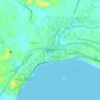
Naam: Topografische kaart Weligama, hoogte, reliëf.
Locatie: Weligama, Matara District, Southern Province, Sri Lanka (5.96910 80.42287 5.98161 80.43598)
Gemiddelde hoogte: 8 m
Minimale hoogte: -1 m
Maximale hoogte: 31 m
Weligama (Sinhala: වැලිගම, Tamil: வெலிகாமம்) is a town on the south coast of Sri Lanka, located in Matara District, Southern Province, Sri Lanka, governed by an Urban Council. The name Weligama, literally means "sandy village" which refers to the area's sandy sweep bay. It is approximately 144 kilometres (89 mi) south of Colombo and is situated at an elevation of 9 metres (30 ft) above the sea level.