
Topografische kaart Blunt
Interactieve kaart
Klik op de kaart om de hoogte weer te geven.
Over deze kaart
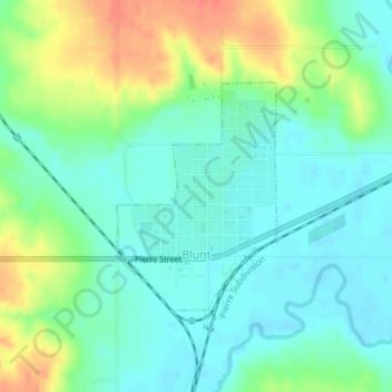
Naam: Topografische kaart Blunt, hoogte, reliëf.
Locatie: Blunt, Hughes County, South Dakota, United States (44.50873 -99.99761 44.52445 -99.98217)
Gemiddelde hoogte: 504 m
Minimale hoogte: 488 m
Maximale hoogte: 536 m
Andere topografische kaarten
Klik op een kaart om zijn topografie, zijn hoogte en zijn reliëf te bekijken.
Pierre
United States > South Dakota > Hughes County
Pierre, Hughes County, South Dakota, 57501, United States
Gemiddelde hoogte: 469 m
North Bend Lakeside Use Area
United States > South Dakota > Hughes County
North Bend Lakeside Use Area, Big Bend District, Hughes County, South Dakota, United States
Gemiddelde hoogte: 466 m