
Topografische kaart Kendujhar
Interactieve kaart
Klik op de kaart om de hoogte weer te geven.
Over deze kaart
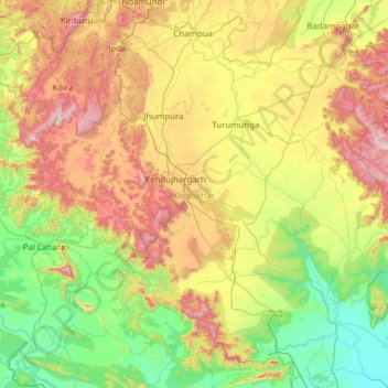
Naam: Topografische kaart Kendujhar, hoogte, reliëf.
Locatie: Kendujhar, Odisha, India (21.01581 85.18423 22.16259 86.37039)
Gemiddelde hoogte: 371 m
Minimale hoogte: 20 m
Maximale hoogte: 1.150 m
The highlands consist of clusters of rugged crags and the mountaintops appear to be sharply ridged or peaked, however they have extensive tablelands on their summits. In some areas, isolated hills rise abruptly from the plains, but most areas have a general elevation of over 600m. The highlands form the watershed for a number of rivers, including the Baitarani River.
Andere topografische kaarten
Klik op een kaart om zijn topografie, zijn hoogte en zijn reliëf te bekijken.
Behera
India > Odisha > Bargarh Sadar > Behera
Behera, Bargarh Sadar, Bargarh, Odisha, India
Gemiddelde hoogte: 172 m