
Topografische kaart Jayapura
Interactieve kaart
Klik op de kaart om de hoogte weer te geven.
Over deze kaart
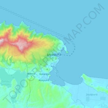
Naam: Topografische kaart Jayapura, hoogte, reliëf.
Locatie: Jayapura, Papua, 99111, Indonesia (-2.69875 140.54374 -2.37875 140.86374)
Gemiddelde hoogte: 149 m
Minimale hoogte: 0 m
Maximale hoogte: 1.660 m
The topography of Jayapura varies from valleys to hills, plateaus, and mountains up to 700 metres (2,300 ft) above sea level. Jayapura overlooks the Yos Sudarso Bay. Jayapura is about 94,000 hectares (230,000 acres) in area, and is divided into five districts. Around 30% of the area is inhabited, with the remainder consisting of a rough terrain, swamps, and protected forest.