
Topografische kaart Poole
Klik op de kaart om de hoogte weer te geven.
Over deze kaart
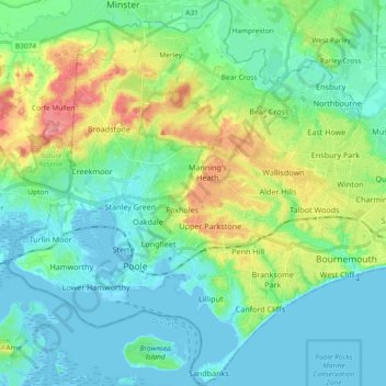
Naam: Topografische kaart Poole, hoogte, reliëf.
Gemiddelde hoogte: 23 m
Minimale hoogte: -7 m
Maximale hoogte: 89 m
Andere topografische kaarten
Klik op een kaart om zijn topografie, zijn hoogte en zijn reliëf te bekijken.
East Parley Common
United Kingdom > England > Bournemouth, Christchurch and Poole > Hurn
Gemiddelde hoogte: 13 m
Highcliffe-on-Sea
United Kingdom > England > Bournemouth, Christchurch and Poole
Gemiddelde hoogte: 19 m
Hengistbury Head
United Kingdom > England > Bournemouth, Christchurch and Poole > Bournemouth
In 1910 the first international aviation meeting ever held in Britain took place on a specially laid out aerodrome consisting of a mile of grassland between the "Double Dykes" and the nearby village of Tuckton. About twenty pioneer aviators from around the world participated in various competitions including…
Gemiddelde hoogte: 0 m
Throop
United Kingdom > England > Bournemouth, Christchurch and Poole > Bournemouth
Gemiddelde hoogte: 13 m
Kinson
United Kingdom > England > Bournemouth, Christchurch and Poole > Bournemouth
Gemiddelde hoogte: 26 m
Upton Heath Nature Reserve
United Kingdom > England > Bournemouth, Christchurch and Poole > Poole
Gemiddelde hoogte: 40 m
Bear Cross
United Kingdom > England > Bournemouth, Christchurch and Poole > Bournemouth
Gemiddelde hoogte: 30 m
St Catherine's Hill
United Kingdom > England > Bournemouth, Christchurch and Poole > Christchurch
Gemiddelde hoogte: 10 m
Redhill Park
United Kingdom > England > Bournemouth, Christchurch and Poole > Bournemouth > Talbot Village
Gemiddelde hoogte: 33 m
Hamworthy Park
United Kingdom > England > Bournemouth, Christchurch and Poole > Poole
Gemiddelde hoogte: 2 m
Kings Park
United Kingdom > England > Bournemouth, Christchurch and Poole > Bournemouth
Gemiddelde hoogte: 31 m
Holes Bay
United Kingdom > England > Bournemouth, Christchurch and Poole > Poole
Gemiddelde hoogte: 4 m
Island in the Stour
United Kingdom > England > Bournemouth, Christchurch and Poole > Poole > Merley
Gemiddelde hoogte: 28 m
Holdenhurst
United Kingdom > England > Bournemouth, Christchurch and Poole > Bournemouth
Gemiddelde hoogte: 12 m
Kinson
United Kingdom > England > Bournemouth, Christchurch and Poole > Bournemouth
Gemiddelde hoogte: 26 m