
Topografische kaart Waddington
Interactieve kaart
Klik op de kaart om de hoogte weer te geven.
Waddington
During the Ice Age, most of the region surrounding Waddington was covered by ice sheets and this has influenced the topography and nature of the soils. Waddington's cliff-top position means it is 226 ft (69 m) above sea level, giving it commanding views over the River Witham valley.
Over deze kaart
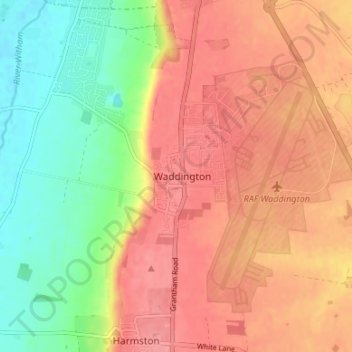
Naam: Topografische kaart Waddington, hoogte, reliëf.
Gemiddelde hoogte: 52 m
Minimale hoogte: 4 m
Maximale hoogte: 85 m
Andere topografische kaarten
Klik op een kaart om zijn topografie, zijn hoogte en zijn reliëf te bekijken.
Washingborough
United Kingdom > England > Lincolnshire > North Kesteven > Washingborough
Gemiddelde hoogte: 33 m
Kirkby la Thorpe
United Kingdom > England > Lincolnshire > North Kesteven > Kirkby la Thorpe
Gemiddelde hoogte: 12 m
Threekingham
United Kingdom > England > Lincolnshire > North Kesteven > Threekingham
Gemiddelde hoogte: 22 m
Scredington
United Kingdom > England > Lincolnshire > North Kesteven > Scredington
Gemiddelde hoogte: 13 m
Carlton-le-Moorland
United Kingdom > England > Lincolnshire > North Kesteven > Carlton le Moorland
Gemiddelde hoogte: 13 m
South Kyme
United Kingdom > England > Lincolnshire > North Kesteven > South Kyme
Gemiddelde hoogte: 3 m
Silk Willoughby
United Kingdom > England > Lincolnshire > North Kesteven > Silk Willoughby
Gemiddelde hoogte: 22 m
North Scarle
United Kingdom > England > Lincolnshire > North Kesteven > North Scarle
Gemiddelde hoogte: 10 m
South Rauceby
United Kingdom > England > Lincolnshire > North Kesteven > South Rauceby
Gemiddelde hoogte: 47 m
Billinghay
United Kingdom > England > Lincolnshire > North Kesteven
The settlement is mentioned in the Domesday Book. The name originates from a Saxon name for a fishery. The topography in ancient times would have been that of a small settlement on a gravel mound surrounded by marsh which was flooded in winter. After the draining of the fens in the late 18th century the area…
Gemiddelde hoogte: 4 m
Washingborough
United Kingdom > England > Lincolnshire > North Kesteven > Washingborough
Gemiddelde hoogte: 20 m
Sleaford
United Kingdom > England > Lincolnshire > North Kesteven > Quarrington
Although hardly damaged in the First and Second World Wars, Sleaford has close links with the Royal Air Force due to proximity to several RAF bases, including RAF Cranwell and RAF Waddington. Lincolnshire's topography – flat and open countryside – and its location in the east of the country made it ideal…
Gemiddelde hoogte: 18 m
Threekingham
United Kingdom > England > Lincolnshire > North Kesteven > Threekingham
Gemiddelde hoogte: 30 m