
Topografische kaart Wiesbaden
Interactieve kaart
Klik op de kaart om de hoogte weer te geven.
Wiesbaden
The highest point of the Wiesbaden municipality is located northwest of the city center near the summit of the Hohe Wurzel, with an elevation of 608 metres (1,995 ft) above sea level. The lowest point is the harbour entrance of Schierstein at 83 metres (272 ft) above sea level. The central square (the Schlossplatz, or palace square) is at an elevation of 115 metres (377 ft).
Over deze kaart
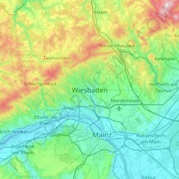
Naam: Topografische kaart Wiesbaden, hoogte, reliëf.
Locatie: Wiesbaden, Hesse, 15183, Germany (49.92204 8.08166 50.24204 8.40166)
Gemiddelde hoogte: 258 m
Minimale hoogte: 79 m
Maximale hoogte: 880 m