
Topografische kaart Bowman County
Interactieve kaart
Klik op de kaart om de hoogte weer te geven.
Over deze kaart
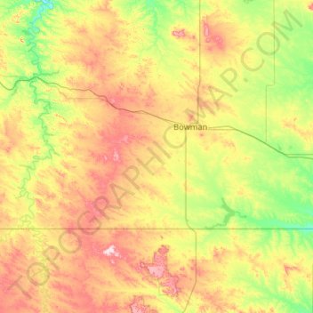
Naam: Topografische kaart Bowman County, hoogte, reliëf.
Locatie: Bowman County, North Dakota, United States of America (45.94513 -104.04682 46.28085 -102.99556)
Gemiddelde hoogte: 899 m
Minimale hoogte: 791 m
Maximale hoogte: 1.099 m
Andere topografische kaarten
Klik op een kaart om zijn topografie, zijn hoogte en zijn reliëf te bekijken.
Haynes
United States of America > North Dakota > Haynes > Haynes
Haynes, Adams County, North Dakota, United States of America
Gemiddelde hoogte: 790 m
Hannah
United States of America > North Dakota > Hannah
Hannah, Cavalier County, North Dakota, United States of America
Gemiddelde hoogte: 476 m
Barney
United States of America > North Dakota > Barney
Barney, Richland County, North Dakota, United States of America
Gemiddelde hoogte: 316 m
Flaxton
United States of America > North Dakota > Flaxton > Flaxton
Flaxton, Burke County, North Dakota, United States of America
Gemiddelde hoogte: 590 m
Avoca
United States of America > North Dakota > Avoca
Avoca, Williams County, North Dakota, United States of America
Gemiddelde hoogte: 625 m
New England
United States of America > North Dakota > New England
New England, Hettinger County, North Dakota, 58647, United States of America
Gemiddelde hoogte: 793 m
Buxton
United States of America > North Dakota > Buxton
Buxton, Traill County, North Dakota, United States of America
Gemiddelde hoogte: 285 m
Billings County
United States of America > North Dakota
Billings County, North Dakota, United States of America
Gemiddelde hoogte: 790 m
Leith
United States of America > North Dakota > Leith
Leith, Grant County, North Dakota, United States of America
Gemiddelde hoogte: 714 m