
Topografische kaart Jelenia Góra
Interactieve kaart
Klik op de kaart om de hoogte weer te geven.
Over deze kaart
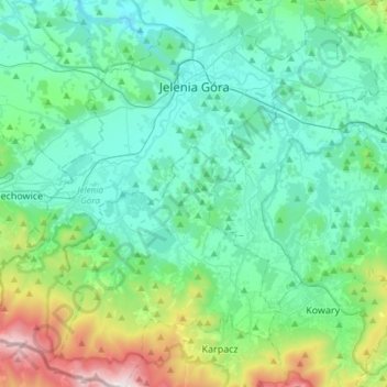
Naam: Topografische kaart Jelenia Góra, hoogte, reliëf.
Gemiddelde hoogte: 580 m
Minimale hoogte: 288 m
Maximale hoogte: 1.506 m
The central suburb of Jelenia Góra possesses many historical and architectural structures of great significance, including the 17th-century Town Hall, baroque churches and a restored central marketplace as well as parks and gardens. The name of the town translates to Deer Mountain in Polish and the original German name due to its geographical and topographical location. The nearby Karkonosze National Park, visited by over 1.5 million tourists annually, has its headquarters in Jelenia Góra.
Andere topografische kaarten
Klik op een kaart om zijn topografie, zijn hoogte en zijn reliëf te bekijken.
Sobieszów
Poland > Lower Silesian Voivodeship > Jelenia Góra
Sobieszów, Jelenia Góra, Lower Silesian Voivodeship, 58-570, Poland
Gemiddelde hoogte: 411 m
Karkonosze
Poland > Lower Silesian Voivodeship > Jelenia Góra
Karkonosze, Jelenia Góra, Lower Silesian Voivodeship, Poland
Gemiddelde hoogte: 1.196 m
Jelenia Góra
Poland > Lower Silesian Voivodeship > Jelenia Góra
Jelenia Góra, Lower Silesian Voivodeship, Poland
Gemiddelde hoogte: 518 m