
Doe een donatie
Rust jezelf uit voor je volgende avontuur:
Als Amazon-partner verdient deze site een commissie op in aanmerking komende aankopen, zonder extra kosten voor jou.
Topografische kaart Gerlach
Klik op de kaart om de hoogte weer te geven.
Doe een donatie
Rust jezelf uit voor je volgende avontuur:
Als Amazon-partner verdient deze site een commissie op in aanmerking komende aankopen, zonder extra kosten voor jou.
Gerlach
According to the United States Census Bureau, the Gerlach CDP has a total area of 3.1 square miles (8.0 km2), all land. Its elevation is 3,944 ft (1,202 m). Gerlach is approximately 100 miles (160 km) north of Reno, Nevada.
Doe een donatie
Rust jezelf uit voor je volgende avontuur:
Als Amazon-partner verdient deze site een commissie op in aanmerking komende aankopen, zonder extra kosten voor jou.
Over deze kaart
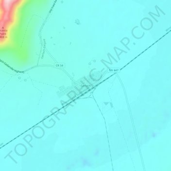
Naam: Topografische kaart Gerlach, hoogte, reliëf.
Locatie: Gerlach, Washoe County, Nevada, United States (40.63181 -119.37626 40.67181 -119.33626)
Gemiddelde hoogte: 1.208 m
Minimale hoogte: 1.171 m
Maximale hoogte: 1.510 m
Doe een donatie
Rust jezelf uit voor je volgende avontuur:
Als Amazon-partner verdient deze site een commissie op in aanmerking komende aankopen, zonder extra kosten voor jou.
Andere topografische kaarten
Klik op een kaart om zijn topografie, zijn hoogte en zijn reliëf te bekijken.
Reno
United States > Nevada > Washoe County
Reno is characterized by its diverse topography, which is shaped by its elevation and the surrounding mountain ranges. Situated at an average elevation of approximately 4,500 feet (about 1,370 meters), the city is nestled in a high desert region that features a mix of flat valleys and gently rolling hills.…
Gemiddelde hoogte: 1.650 m
Reno
United States > Nevada > Washoe County
Reno is just east of the Sierra Nevada on the western edge of the Great Basin at an elevation of about 4,400 feet (1,300 m) above sea level. Numerous faults exist throughout the region. Most of these are normal (vertical motion) faults associated with the uplift of the various mountain ranges, including the…
Gemiddelde hoogte: 1.650 m
Doe een donatie
Rust jezelf uit voor je volgende avontuur:
Als Amazon-partner verdient deze site een commissie op in aanmerking komende aankopen, zonder extra kosten voor jou.
Incline Village-Crystal Bay
United States > Nevada > Washoe County > Incline Village-Crystal Bay
Gemiddelde hoogte: 2.173 m
Spooner Lake & Backcountry State Park
United States > Nevada > Washoe County > Incline Village-Crystal Bay
Gemiddelde hoogte: 2.108 m
Reno
United States > Nevada > Washoe County
Reno is just east of the Sierra Nevada, on the western edge of the Great Basin at an elevation of about 4,400 feet (1,300 m) above sea level. Numerous faults exist throughout the region. Most of these are normal (vertical motion) faults associated with the uplift of the various mountain ranges, including the…
Gemiddelde hoogte: 1.650 m
Doe een donatie
Rust jezelf uit voor je volgende avontuur:
Als Amazon-partner verdient deze site een commissie op in aanmerking komende aankopen, zonder extra kosten voor jou.
Doe een donatie
Rust jezelf uit voor je volgende avontuur:
Als Amazon-partner verdient deze site een commissie op in aanmerking komende aankopen, zonder extra kosten voor jou.
Reno
United States > Nevada > Washoe County
Reno is just east of the Sierra Nevada, on the western edge of the Great Basin at an elevation of about 4,400 feet (1,300 m) above sea level. Numerous faults exist throughout the region. Most of these are normal (vertical motion) faults associated with the extension of the earth's lithosphere and the uplift of…
Gemiddelde hoogte: 1.650 m
Reno
United States > Nevada > Washoe County
Reno is just east of the Sierra Nevada, on the western edge of the Great Basin at an elevation of about 4,400 feet (1,300 m) above sea level. Numerous faults exist throughout the region. Most of these are normal (vertical motion) faults associated with the uplift of the various mountain ranges, including the…
Gemiddelde hoogte: 1.650 m
Doe een donatie
Rust jezelf uit voor je volgende avontuur:
Als Amazon-partner verdient deze site een commissie op in aanmerking komende aankopen, zonder extra kosten voor jou.
Reno
United States > Nevada > Washoe County
Reno is just east of the Sierra Nevada, on the western edge of the Great Basin at an elevation of about 4,400 feet (1,300 m) above sea level. Numerous faults exist throughout the region. Most of these are normal (vertical motion) faults associated with the extension of the earth's lithosphere and the uplift of…
Gemiddelde hoogte: 1.650 m
Reno
United States > Nevada > Washoe County
Reno is just east of the Sierra Nevada, on the western edge of the Great Basin at an elevation of about 4,400 feet (1,300 m) above sea level. Numerous faults exist throughout the region. Most of these are normal (vertical motion) faults associated with the extension of the earth's lithosphere and the uplift of…
Gemiddelde hoogte: 1.650 m
Doe een donatie
Rust jezelf uit voor je volgende avontuur:
Als Amazon-partner verdient deze site een commissie op in aanmerking komende aankopen, zonder extra kosten voor jou.
Incline Village-Crystal Bay
United States > Nevada > Washoe County > Incline Village-Crystal Bay
Gemiddelde hoogte: 2.173 m
Reno
United States > Nevada > Washoe County
Reno is just east of the Sierra Nevada, on the western edge of the Great Basin at an elevation of about 4,400 feet (1,300 m) above sea level. Numerous faults exist throughout the region. Most of these are normal (vertical motion) faults associated with the uplift of the various mountain ranges, including the…
Gemiddelde hoogte: 1.650 m
Oxbow Nature Study Area
United States > Nevada > Washoe County > Reno > West Reno
Gemiddelde hoogte: 1.415 m
Doe een donatie
Rust jezelf uit voor je volgende avontuur:
Als Amazon-partner verdient deze site een commissie op in aanmerking komende aankopen, zonder extra kosten voor jou.