
Topografische kaart Indiana Dunes National Park
Interactieve kaart
Klik op de kaart om de hoogte weer te geven.
Over deze kaart
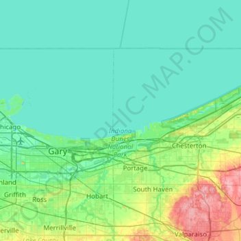
Naam: Topografische kaart Indiana Dunes National Park, hoogte, reliëf.
Gemiddelde hoogte: 188 m
Minimale hoogte: 172 m
Maximale hoogte: 267 m
Miller Woods is located in Miller Beach, Indiana. It is accessed through the Paul H. Douglas Center for Environmental Education on Lake Street. The area is dominated by ridge and swale topography. the ridges or swells are beach and dune sand. They date from the post Glacial Lake Nipissing period some 3000 years before present. The swales are the depressions between the ridges. They are generally either ponds or marshes.