
Topografische kaart Réville
Interactieve kaart
Klik op de kaart om de hoogte weer te geven.
Over deze kaart
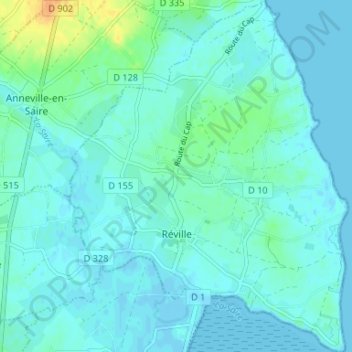
Naam: Topografische kaart Réville, hoogte, reliëf.
Gemiddelde hoogte: 5 m
Minimale hoogte: -2 m
Maximale hoogte: 29 m
Andere topografische kaarten
Klik op een kaart om zijn topografie, zijn hoogte en zijn reliëf te bekijken.
Le Hameau Craville
France > Normandie > Manche > Teurthéville-Hague
Le Hameau Craville, Teurthéville-Hague, Cherbourg, Manche, Normandie, France métropolitaine, 50690, France
Gemiddelde hoogte: 85 m
Hamel de Bas
France > Normandie > Manche > Carentan-les-Marais > Les Veys
Hamel de Bas, Les Veys, Carentan-les-Marais, Saint-Lô, Manche, Normandie, France métropolitaine, 50500, France
Gemiddelde hoogte: 13 m
Buais-Les-Monts
France > Normandie > Manche > Buais-Les-Monts
Buais-Les-Monts, Avranches, Manche, Normandie, France métropolitaine, 50640, France
Gemiddelde hoogte: 183 m
Montmartin-sur-Mer
France > Normandie > Manche > Montmartin-sur-Mer
Montmartin-sur-Mer, Coutances, Manche, Normandie, France métropolitaine, 50590, France
Gemiddelde hoogte: 31 m