
Topografische kaart Kerdoret
Interactieve kaart
Klik op de kaart om de hoogte weer te geven.
Over deze kaart
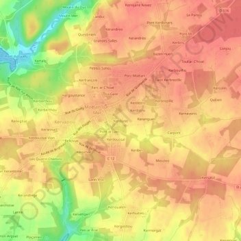
Naam: Topografische kaart Kerdoret, hoogte, reliëf.
Gemiddelde hoogte: 47 m
Minimale hoogte: 0 m
Maximale hoogte: 67 m
Andere topografische kaarten
Klik op een kaart om zijn topografie, zijn hoogte en zijn reliëf te bekijken.
Kerguevellic
France > Bretagne > Finistère > Kervaziou
Kerguevellic, Kervaziou, Moëlan-sur-Mer, Quimper, Finistère, Bretagne, France métropolitaine, 29350, France
Gemiddelde hoogte: 46 m
Petites Salles
France > Bretagne > Finistère > Kervaziou
Petites Salles, Kervaziou, Moëlan-sur-Mer, Quimper, Finistère, Bretagne, France métropolitaine, 29350, France
Gemiddelde hoogte: 46 m
Parc ar C'hoat
France > Bretagne > Finistère > Kervaziou
Parc ar C'hoat, Kervaziou, Moëlan-sur-Mer, Quimper, Finistère, Bretagne, France métropolitaine, 29350, France
Gemiddelde hoogte: 46 m