
Topografische kaart Ladysmith
Interactieve kaart
Klik op de kaart om de hoogte weer te geven.
Over deze kaart
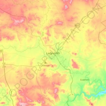
Naam: Topografische kaart Ladysmith, hoogte, reliëf.
Gemiddelde hoogte: 1.098 m
Minimale hoogte: 792 m
Maximale hoogte: 1.439 m
Andere topografische kaarten
Klik op een kaart om zijn topografie, zijn hoogte en zijn reliëf te bekijken.
Emnambithi/Ladysmith Local Municipality
Zuid-Afrika > KwaZoeloe-Natal > Uthukela District Municipality
Emnambithi/Ladysmith Local Municipality, Uthukela District Municipality, KwaZoeloe-Natal, 3370, Zuid-Afrika
Gemiddelde hoogte: 1.244 m