
Topografische kaart City of London
Interactieve kaart
Klik op de kaart om de hoogte weer te geven.
Over deze kaart
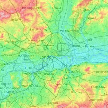
Naam: Topografische kaart City of London, hoogte, reliëf.
Locatie: City of London, England, EC2V 5AE, United Kingdom (51.35562 -0.25200 51.67562 0.06800)
Gemiddelde hoogte: 42 m
Minimale hoogte: -3 m
Maximale hoogte: 166 m
The elevation of the City ranges from sea level at the Thames to 21.6 metres (71 ft) at the junction of High Holborn and Chancery Lane. Two small but notable hills are within the historic core, Ludgate Hill to the west and Cornhill to the east. Between them ran the Walbrook, one of the many "lost" rivers or streams of London (another is the Fleet).
Andere topografische kaarten
Klik op een kaart om zijn topografie, zijn hoogte en zijn reliëf te bekijken.
The Fleet
United Kingdom > England > City of London > City of London
The Fleet, London Borough of Camden, City of London, Greater London, England, NW1 8NZ, United Kingdom
Gemiddelde hoogte: 41 m