
Topografische kaart Madison
Interactieve kaart
Klik op de kaart om de hoogte weer te geven.
Over deze kaart
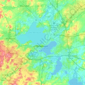
Naam: Topografische kaart Madison, hoogte, reliëf.
Locatie: Madison, Dane County, Wisconsin, United States (42.99815 -89.57166 43.17192 -89.23208)
Gemiddelde hoogte: 284 m
Minimale hoogte: 256 m
Maximale hoogte: 369 m
The city is sometimes described as The City of Four Lakes, comprising the four successive lakes of the Yahara River: Lake Mendota ("Fourth Lake"), Lake Monona ("Third Lake"), Lake Waubesa ("Second Lake") and Lake Kegonsa ("First Lake"), although Waubesa and Kegonsa are not actually in Madison, but just south of it. A fifth smaller lake, Lake Wingra, is within the city as well; it is connected to the Yahara River chain by Wingra Creek. The Yahara flows into the Rock River, which flows into the Mississippi River. Downtown Madison is located on an isthmus between Lakes Mendota and Monona. The city's trademark of "Lake, City, Lake" reflects this geography. The city's lowest elevation is Lake Monona, at 845 ft (258 m). The highest elevation is located along S. Pleasant View Rd. on the far west side of the city, atop a portion of a terminal moraine of the Green Bay Lobe of the Wisconsin Glaciation, at 1,192 ft (363 m).
Andere topografische kaarten
Klik op een kaart om zijn topografie, zijn hoogte en zijn reliëf te bekijken.
Discovery Garden
United States > Wisconsin > Dane County > McFarland
Discovery Garden, 5920, McFarland, Blooming Grove, Dane County, Wisconsin, 53558, United States
Gemiddelde hoogte: 268 m
Waunakee
United States > Wisconsin > Dane County
Waunakee, Dane County, Wisconsin, 53597, United States
Gemiddelde hoogte: 286 m
Town of Dunn
United States > Wisconsin > Dane County
Town of Dunn, Dane County, Wisconsin, United States
Gemiddelde hoogte: 273 m
Sun Prairie
United States > Wisconsin > Dane County
Sun Prairie, Dane County, Wisconsin, United States
Gemiddelde hoogte: 293 m
DeForest
United States > Wisconsin > Dane County
DeForest, Dane County, Wisconsin, 53532, United States
Gemiddelde hoogte: 290 m
Table Bluff
United States > Wisconsin > Dane County > Town of Berry
Table Bluff, Town of Berry, Dane County, Wisconsin, 53528, United States
Gemiddelde hoogte: 306 m
Oregon
United States > Wisconsin > Dane County
Oregon, Dane County, Wisconsin, 53575, United States
Gemiddelde hoogte: 298 m
Town of Pleasant Springs
United States > Wisconsin > Dane County
Town of Pleasant Springs, Dane County, Wisconsin, United States
Gemiddelde hoogte: 277 m
Town of Roxbury
United States > Wisconsin > Dane County > Town of Roxbury
Town of Roxbury, Dane County, Wisconsin, 53578:53583, United States
Gemiddelde hoogte: 282 m
Windsor
United States > Wisconsin > Dane County > Windsor
Windsor, Dane County, Wisconsin, United States
Gemiddelde hoogte: 293 m
Dane
United States > Wisconsin > Dane County > Dane
Dane, Dane County, Wisconsin, United States
Gemiddelde hoogte: 327 m
Stoughton
United States > Wisconsin > Dane County > Stoughton
Stoughton, Dane County, Wisconsin, 53589, United States
Gemiddelde hoogte: 270 m
Middleton
United States > Wisconsin > Dane County
Middleton, Dane County, Wisconsin, 53562, United States
Gemiddelde hoogte: 290 m
Stoughton
United States > Wisconsin > Dane County
Stoughton, Dane County, Wisconsin, 53589, United States
Gemiddelde hoogte: 269 m
Verona
United States > Wisconsin > Dane County
Verona, Dane County, Wisconsin, 53593, United States
Gemiddelde hoogte: 308 m