Topografische kaart Galveston
Klik op de kaart om de hoogte weer te geven.
Galveston
On September 8, 1900, the island was struck by a devastating hurricane. This event holds the record as the United States' deadliest natural disaster. The city was devastated, and an estimated 6,000 to 8,000 people on the island were killed. Following the storm, a 10-mile (16 km) long, 17 foot (5.2 m) high seawall was built to protect the city from floods and hurricane storm surges. A team of engineers including Henry Martyn Robert (Robert's Rules of Order) designed the plan to raise much of the existing city to a sufficient elevation behind a seawall so that confidence in the city could be maintained.
Over deze kaart
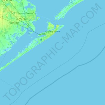
Naam: Topografische kaart Galveston, hoogte, reliëf.
Locatie: Galveston, Galveston County, Texas, United States (28.99634 -95.12994 29.39940 -94.52566)
Gemiddelde hoogte: 1 m
Minimale hoogte: -7 m
Maximale hoogte: 15 m
Andere topografische kaarten
Klik op een kaart om zijn topografie, zijn hoogte en zijn reliëf te bekijken.


San Luis Pass
United States > Texas > Galveston County > Galveston
Tides cause daily variations in topography, and occasionally, storms more drastically change the topography of the pass.
Gemiddelde hoogte: 0 m

Texas City Terminal Junction
United States > Texas > Galveston County > Hitchcock
Gemiddelde hoogte: 2 m
San Luis Pass
United States > Texas > Galveston County > Galveston
Tides cause daily variations in topography, and occasionally, storms more drastically change the topography of the pass.
Gemiddelde hoogte: 0 m
Bacliff
United States > Texas > Galveston County
After Hurricane Ike hit Texas in September 2008, Galveston County officials offered a debris removal program to residents in unincorporated areas, including Bacliff. Flooding from hurricane Ike was minimized due in part to Bacliff's relatively high elevation of 16 feet.
Gemiddelde hoogte: 4 m
League City
United States > Texas > Galveston County > League City > League City
Gemiddelde hoogte: 7 m