
Topografische kaart Ferns
Interactieve kaart
Klik op de kaart om de hoogte weer te geven.
Over deze kaart
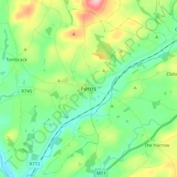
Naam: Topografische kaart Ferns, hoogte, reliëf.
Gemiddelde hoogte: 60 m
Minimale hoogte: 8 m
Maximale hoogte: 182 m
The 19th-century population peaked in 1851, but never reached the levels of medieval times. Lewis's Topography of 1834 claimed the town "consists chiefly of one irregular street, and contains 106 houses indifferently built, retaining no trace of its ancient importance". The Abbey, St.Peter's Church (Catholic and Anglican), and the remainder of the great cathedral are regarded as historic, holy places, and are still regarded as churches. This includes the abbey, which has the title of an abbey church.