
Doe een donatie
Rust jezelf uit voor je volgende avontuur:
Als Amazon-partner verdient deze site een commissie op in aanmerking komende aankopen, zonder extra kosten voor jou.
Topografische kaart McCaysville
Klik op de kaart om de hoogte weer te geven.
Doe een donatie
Rust jezelf uit voor je volgende avontuur:
Als Amazon-partner verdient deze site een commissie op in aanmerking komende aankopen, zonder extra kosten voor jou.
McCaysville
McCaysville's weather is temperate due to its elevation and location in the southern Appalachians. Summers are warm with average highs in the middle 80s and lows in the lower 60s. Winters are cool with average highs in the 40s and average lows in the 20s. Rainfall is abundant with the yearly average approaching 67 inches and occurring on 127 days. Snowfall usually occurs on several occasions during the winter months and can range from a light dusting to the occasional significant storm. The most significant snow storm to hit the area occurred March 12–14, 1993, when the area received approximately 40 inches in what eastern seaboard residents often refer to as "the storm of the century". The average first frost occurs in mid-October with the average last frost occurring in late April.
Doe een donatie
Rust jezelf uit voor je volgende avontuur:
Als Amazon-partner verdient deze site een commissie op in aanmerking komende aankopen, zonder extra kosten voor jou.
Over deze kaart
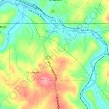
Naam: Topografische kaart McCaysville, hoogte, reliëf.
Locatie: McCaysville, Fannin County, Georgia, United States (34.97250 -84.38621 34.98815 -84.35309)
Gemiddelde hoogte: 484 m
Minimale hoogte: 437 m
Maximale hoogte: 548 m
Doe een donatie
Rust jezelf uit voor je volgende avontuur:
Als Amazon-partner verdient deze site een commissie op in aanmerking komende aankopen, zonder extra kosten voor jou.
Andere topografische kaarten
Klik op een kaart om zijn topografie, zijn hoogte en zijn reliëf te bekijken.
Doe een donatie
Rust jezelf uit voor je volgende avontuur:
Als Amazon-partner verdient deze site een commissie op in aanmerking komende aankopen, zonder extra kosten voor jou.
Springer Mountain
United States > Georgia > Fannin County
Springer Mountain is a mountain located in the Chattahoochee National Forest on the border of Fannin and Gilmer counties. Located in the Blue Ridge Mountains in northern Georgia, the mountain has an elevation of about 3,782 feet (1,153 m). Springer Mountain serves as the southern terminus for the Appalachian…
Gemiddelde hoogte: 941 m
Doe een donatie
Rust jezelf uit voor je volgende avontuur:
Als Amazon-partner verdient deze site een commissie op in aanmerking komende aankopen, zonder extra kosten voor jou.
Doe een donatie
Rust jezelf uit voor je volgende avontuur:
Als Amazon-partner verdient deze site een commissie op in aanmerking komende aankopen, zonder extra kosten voor jou.
Doe een donatie
Rust jezelf uit voor je volgende avontuur:
Als Amazon-partner verdient deze site een commissie op in aanmerking komende aankopen, zonder extra kosten voor jou.
Springer Mountain
United States > Georgia > Fannin County
Springer Mountain is a mountain located in the Chattahoochee National Forest on the border of Fannin and Gilmer counties. Located in the Blue Ridge Mountains in northern Georgia, the mountain has an elevation of about 3,782 feet (1,153 m). Springer Mountain serves as the southern terminus for the Appalachian…
Gemiddelde hoogte: 941 m