
Topografische kaart Delaware
Interactieve kaart
Klik op de kaart om de hoogte weer te geven.
Over deze kaart
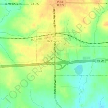
Naam: Topografische kaart Delaware, hoogte, reliëf.
Locatie: Delaware, Delaware County, Iowa, 52036, United States (42.46656 -91.35146 42.47746 -91.32638)
Gemiddelde hoogte: 322 m
Minimale hoogte: 304 m
Maximale hoogte: 339 m
Andere topografische kaarten
Klik op een kaart om zijn topografie, zijn hoogte en zijn reliëf te bekijken.
Ryan
United States > Iowa > Delaware County
Ryan, Delaware County, Iowa, United States
Gemiddelde hoogte: 310 m
Greeley
United States > Iowa > Delaware County
Greeley, Delaware County, Iowa, United States
Gemiddelde hoogte: 347 m
Colesburg
United States > Iowa > Delaware County
Colesburg, Delaware County, Iowa, United States
Gemiddelde hoogte: 345 m
Delhi
United States > Iowa > Delaware County
Delhi, Delaware County, Iowa, United States
Gemiddelde hoogte: 320 m
York
United States > Iowa > Delaware County
York, Delaware County, Iowa, United States
Gemiddelde hoogte: 340 m
Dundee
United States > Iowa > Delaware County
Dundee, Delaware County, Iowa, United States
Gemiddelde hoogte: 311 m
Backbone State Park
United States > Iowa > Delaware County
Backbone State Park, Delaware County, Iowa, United States
Gemiddelde hoogte: 333 m
Earlville
United States > Iowa > Delaware County
Earlville, Delaware County, Iowa, United States
Gemiddelde hoogte: 310 m
Hopkinton
United States > Iowa > Delaware County
Hopkinton, Delaware County, Iowa, United States
Gemiddelde hoogte: 269 m
Masonville
United States > Iowa > Delaware County
Masonville, Delaware County, Iowa, United States
Gemiddelde hoogte: 309 m
Manchester
United States > Iowa > Delaware County
Manchester, Delaware County, Iowa, 52057, United States
Gemiddelde hoogte: 296 m