
Topografische kaart Lecompton
Interactieve kaart
Klik op de kaart om de hoogte weer te geven.
Over deze kaart
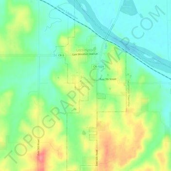
Naam: Topografische kaart Lecompton, hoogte, reliëf.
Locatie: Lecompton, Douglas County, Kansas, United States (39.01507 -95.40503 39.05736 -95.38194)
Gemiddelde hoogte: 281 m
Minimale hoogte: 250 m
Maximale hoogte: 331 m
Andere topografische kaarten
Klik op een kaart om zijn topografie, zijn hoogte en zijn reliëf te bekijken.
Lawrence
United States > Kansas > Douglas County
Lawrence, Douglas County, Kansas, United States
Gemiddelde hoogte: 265 m
Baldwin City
United States > Kansas > Douglas County
Baldwin City, Douglas County, Kansas, United States
Gemiddelde hoogte: 323 m
Lawrence
United States > Kansas > Douglas County > Lawrence
Lawrence, Douglas County, Kansas, 66044, United States
Gemiddelde hoogte: 283 m
Eudora
United States > Kansas > Douglas County > Eudora > Eudora
Eudora, Douglas County, Kansas, 66025, United States
Gemiddelde hoogte: 258 m
Overlook Park
United States > Kansas > Douglas County
Overlook Park, Kanwaka Township, Douglas County, Kansas, United States
Gemiddelde hoogte: 281 m
Burcham Park
United States > Kansas > Douglas County > Lawrence
Burcham Park, Lawrence, Douglas County, Kansas, 66044, United States
Gemiddelde hoogte: 260 m