
Topografische kaart Lew
Interactieve kaart
Klik op de kaart om de hoogte weer te geven.
Over deze kaart
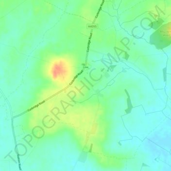
Naam: Topografische kaart Lew, hoogte, reliëf.
Locatie: Lew, West Oxfordshire, Oxfordshire, England, United Kingdom (51.73817 -1.55545 51.76519 -1.50477)
Gemiddelde hoogte: 79 m
Minimale hoogte: 65 m
Maximale hoogte: 106 m
Andere topografische kaarten
Klik op een kaart om zijn topografie, zijn hoogte en zijn reliëf te bekijken.
Alvescot
United Kingdom > England > Oxfordshire > West Oxfordshire
Alvescot, West Oxfordshire, Oxfordshire, England, United Kingdom
Gemiddelde hoogte: 87 m
Ramsden
United Kingdom > England > Oxfordshire > West Oxfordshire
Ramsden, West Oxfordshire, Oxfordshire, England, United Kingdom
Gemiddelde hoogte: 136 m
Cassington
United Kingdom > England > Oxfordshire > West Oxfordshire > Cassington
Cassington, West Oxfordshire, Oxfordshire, England, United Kingdom
Gemiddelde hoogte: 72 m
Mount Skippett
United Kingdom > England > Oxfordshire > West Oxfordshire > Ramsden
Mount Skippett, Ramsden, West Oxfordshire, Oxfordshire, England, OX7 3AP, United Kingdom
Gemiddelde hoogte: 135 m
Standlake
United Kingdom > England > Oxfordshire > West Oxfordshire
Standlake, West Oxfordshire, Oxfordshire, England, United Kingdom
Gemiddelde hoogte: 67 m
Shipton-under-Wychwood
United Kingdom > England > Oxfordshire > West Oxfordshire
Shipton-under-Wychwood, West Oxfordshire, Oxfordshire, England, OX7 6DE, United Kingdom
Gemiddelde hoogte: 131 m
Chadlington
United Kingdom > England > Oxfordshire > West Oxfordshire
Chadlington, West Oxfordshire, Oxfordshire, England, United Kingdom
Gemiddelde hoogte: 161 m
Windrush
United Kingdom > England > Oxfordshire > West Oxfordshire > Witney
Windrush, Witney, West Oxfordshire, Oxfordshire, South East England, England, OX28 4DG, United Kingdom
Gemiddelde hoogte: 87 m
Burford
United Kingdom > England > Oxfordshire > West Oxfordshire > Fulbrook
Burford, Fulbrook, West Oxfordshire, Oxfordshire, England, United Kingdom
Gemiddelde hoogte: 129 m
Woodstock
United Kingdom > England > Oxfordshire > West Oxfordshire > Woodstock
Woodstock, West Oxfordshire, Oxfordshire, South East England, England, United Kingdom
Gemiddelde hoogte: 96 m
Brize Norton
United Kingdom > England > Oxfordshire > West Oxfordshire
Brize Norton, West Oxfordshire, Oxfordshire, England, United Kingdom
Gemiddelde hoogte: 97 m
Enstone
United Kingdom > England > Oxfordshire > West Oxfordshire
Enstone, West Oxfordshire, Oxfordshire, England, United Kingdom
Gemiddelde hoogte: 160 m
Chipping Norton
United Kingdom > England > Oxfordshire > West Oxfordshire > Chipping Norton
Chipping Norton, West Oxfordshire, Oxfordshire, England, United Kingdom
Gemiddelde hoogte: 194 m
Stanton Harcourt
United Kingdom > England > Oxfordshire > West Oxfordshire > Stanton Harcourt
Stanton Harcourt, West Oxfordshire, Oxfordshire, England, United Kingdom
Gemiddelde hoogte: 67 m
Kingham
United Kingdom > England > Oxfordshire > West Oxfordshire
Kingham, West Oxfordshire, Oxfordshire, England, United Kingdom
Gemiddelde hoogte: 130 m
Eynsham
United Kingdom > England > Oxfordshire > West Oxfordshire
Eynsham, West Oxfordshire, Oxfordshire, England, United Kingdom
Gemiddelde hoogte: 75 m
Lyneham
United Kingdom > England > Oxfordshire > West Oxfordshire
Lyneham, West Oxfordshire, Oxfordshire, England, United Kingdom
Gemiddelde hoogte: 130 m
Witney
United Kingdom > England > Oxfordshire > West Oxfordshire
Witney, West Oxfordshire, Oxfordshire, England, United Kingdom
Gemiddelde hoogte: 92 m
Taynton
United Kingdom > England > Oxfordshire > West Oxfordshire
Taynton, West Oxfordshire, Oxfordshire, England, United Kingdom
Gemiddelde hoogte: 152 m
Wilcote
United Kingdom > England > Oxfordshire > West Oxfordshire
Wilcote, North Leigh, West Oxfordshire, Oxfordshire, England, OX7 3EB, United Kingdom
Gemiddelde hoogte: 117 m