
Topografische kaart Tadipatri
Interactieve kaart
Klik op de kaart om de hoogte weer te geven.
Over deze kaart
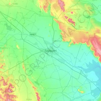
Naam: Topografische kaart Tadipatri, hoogte, reliëf.
Locatie: Tadipatri, Tadpatri, Anantapur, Andhra Pradesh, 515400, India (14.74696 77.84971 15.06696 78.16971)
Gemiddelde hoogte: 273 m
Minimale hoogte: 206 m
Maximale hoogte: 491 m
Tadipatri is located at 14°55′N 78°01′E / 14.92°N 78.02°E / 14.92; 78.02. Its average elevation is 223 metres or 731 feet. Tadipatri lies on the southern bank of Pennar River. Due to Mid Pennar Dam constructed upstream, the section of river in Tadipatri is usually dry throughout the year. Tadipatri is rich in cement grade limestone deposits. The limestone reserves are extending in a triangle from Tadipatri in Anantapur district to Kamalapuram in Kadapa district and Bethamcherla in Kurnool district.