
Topografische kaart Smith Lake
Interactieve kaart
Klik op de kaart om de hoogte weer te geven.
Over deze kaart
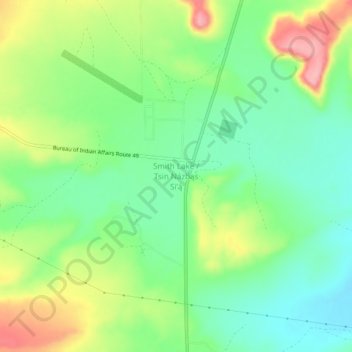
Naam: Topografische kaart Smith Lake, hoogte, reliëf.
Gemiddelde hoogte: 2.221 m
Minimale hoogte: 2.175 m
Maximale hoogte: 2.296 m
Andere topografische kaarten
Klik op een kaart om zijn topografie, zijn hoogte en zijn reliëf te bekijken.
Umbrella Rock
United States > New Mexico > McKinley County
Umbrella Rock, Eastern Navajo Agency, McKinley County, New Mexico, United States
Gemiddelde hoogte: 2.168 m
Mesa Redondita
United States > New Mexico > McKinley County
Mesa Redondita, McKinley County, New Mexico, United States
Gemiddelde hoogte: 2.225 m
China Springs
United States > New Mexico > McKinley County
China Springs, McKinley County, New Mexico, 87317, United States
Gemiddelde hoogte: 2.065 m
Crownpoint
United States > New Mexico > McKinley County > Crownpoint
Crownpoint, Eastern Navajo Agency, McKinley County, New Mexico, 87313, United States
Gemiddelde hoogte: 2.099 m
Zuni Pueblo
United States > New Mexico > McKinley County > Zuni
Zuni Pueblo, Zuni, McKinley County, New Mexico, 87327, United States
Gemiddelde hoogte: 1.944 m
Fort Wingate
United States > New Mexico > McKinley County > Fort Wingate
Fort Wingate, McKinley County, New Mexico, 87316, United States
Gemiddelde hoogte: 2.156 m
Tinian
United States > New Mexico > McKinley County
Tinian, Eastern Navajo Agency, McKinley County, New Mexico, United States
Gemiddelde hoogte: 2.014 m