
Topografische kaart Bellevue
Interactieve kaart
Klik op de kaart om de hoogte weer te geven.
Over deze kaart
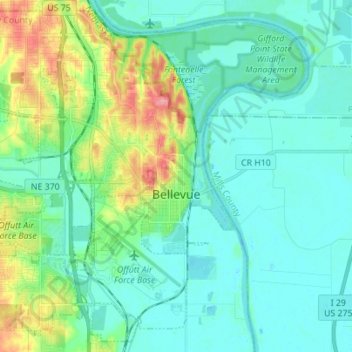
Naam: Topografische kaart Bellevue, hoogte, reliëf.
Locatie: Bellevue, Sarpy County, Nebraska, United States (41.09278 -96.00926 41.19110 -95.87084)
Gemiddelde hoogte: 315 m
Minimale hoogte: 288 m
Maximale hoogte: 385 m
Bellevue is located at an elevation of 1159 ft (353 m). According to the United States Census Bureau, the city has a total area of 16.02 square miles (41.49 km2), of which 15.85 square miles (41.05 km2) is land and 0.17 square miles (0.44 km2) is water. It is bounded on the east by the Missouri River.
Andere topografische kaarten
Klik op een kaart om zijn topografie, zijn hoogte en zijn reliëf te bekijken.
Chalco
United States > Nebraska > Sarpy County
Chalco, Sarpy County, Nebraska, 68138, United States
Gemiddelde hoogte: 346 m
Papillion
United States > Nebraska > Sarpy County
Papillion, Sarpy County, Nebraska, 68046, United States
Gemiddelde hoogte: 338 m
La Vista
United States > Nebraska > Sarpy County
La Vista, Sarpy County, Nebraska, 68128, United States
Gemiddelde hoogte: 330 m
Fontenelle Forest
United States > Nebraska > Sarpy County > Bellevue
Fontenelle Forest, Bellevue, Sarpy County, Nebraska, 68123, United States
Gemiddelde hoogte: 316 m
Prairie Queen Recreation Area
United States > Nebraska > Sarpy County > Papillion
Prairie Queen Recreation Area, Papillion, Sarpy County, Nebraska, United States
Gemiddelde hoogte: 346 m
Gretna
United States > Nebraska > Sarpy County
Gretna, Sarpy County, Nebraska, 68028, United States
Gemiddelde hoogte: 363 m
Springfield
United States > Nebraska > Sarpy County > Springfield
Springfield, Sarpy County, Nebraska, 68059, United States
Gemiddelde hoogte: 344 m