
Topografische kaart Wichita
Interactieve kaart
Klik op de kaart om de hoogte weer te geven.
Over deze kaart
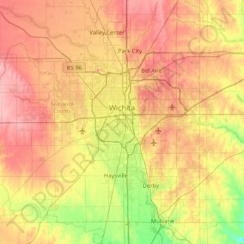
Naam: Topografische kaart Wichita, hoogte, reliëf.
Locatie: Wichita, Sedgwick County, Kansas, United States (37.48902 -97.73435 37.84020 -97.15300)
Gemiddelde hoogte: 408 m
Minimale hoogte: 355 m
Maximale hoogte: 459 m
The city lies on the Arkansas River near the western edge of the Flint Hills in the Wellington-McPherson Lowlands region of the Great Plains. The area's topography is characterized by the broad alluvial plain of the Arkansas River valley and the moderately rolling slopes that rise to the higher lands on either side.
Andere topografische kaarten
Klik op een kaart om zijn topografie, zijn hoogte en zijn reliëf te bekijken.
Haysville
United States > Kansas > Sedgwick County
Haysville, Sedgwick County, Kansas, United States
Gemiddelde hoogte: 388 m
Bentley
United States > Kansas > Sedgwick County
Bentley, Sedgwick County, Kansas, United States
Gemiddelde hoogte: 424 m
Wichita
United States > Kansas > Sedgwick County > Wichita
Wichita, Sedgwick County, Kansas, 67202, United States
Gemiddelde hoogte: 410 m
Derby
United States > Kansas > Sedgwick County > Derby
Derby, Sedgwick County, Kansas, United States
Gemiddelde hoogte: 392 m