
Topografische kaart Paratge Natural Municipal Serra de les Àguiles i Sant Pasqual
Interactieve kaart
Klik op de kaart om de hoogte weer te geven.
Over deze kaart
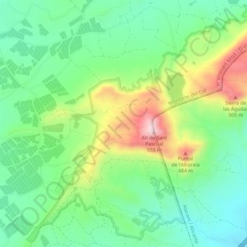
Naam: Topografische kaart Paratge Natural Municipal Serra de les Àguiles i Sant Pasqual, hoogte, reliëf.
Gemiddelde hoogte: 319 m
Minimale hoogte: 203 m
Maximale hoogte: 542 m