
Doe een donatie
Rust jezelf uit voor je volgende avontuur:
Als Amazon-partner verdient deze site een commissie op in aanmerking komende aankopen, zonder extra kosten voor jou.
Topografische kaart Papaikou
Klik op de kaart om de hoogte weer te geven.
Doe een donatie
Rust jezelf uit voor je volgende avontuur:
Als Amazon-partner verdient deze site een commissie op in aanmerking komende aankopen, zonder extra kosten voor jou.
Over deze kaart
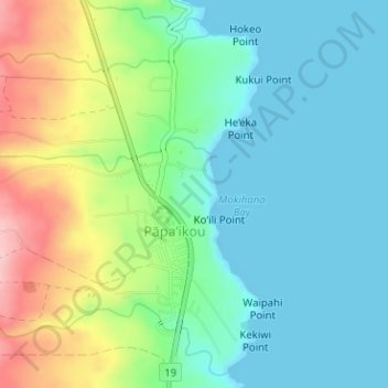
Naam: Topografische kaart Papaikou, hoogte, reliëf.
Locatie: Papaikou, Hawaiʻi County, Hawaii, 96781, United States (19.77683 -155.11498 19.80657 -155.08406)
Gemiddelde hoogte: 51 m
Minimale hoogte: 0 m
Maximale hoogte: 170 m
Doe een donatie
Rust jezelf uit voor je volgende avontuur:
Als Amazon-partner verdient deze site een commissie op in aanmerking komende aankopen, zonder extra kosten voor jou.
Andere topografische kaarten
Klik op een kaart om zijn topografie, zijn hoogte en zijn reliëf te bekijken.
Doe een donatie
Rust jezelf uit voor je volgende avontuur:
Als Amazon-partner verdient deze site een commissie op in aanmerking komende aankopen, zonder extra kosten voor jou.
Kohala
United States > Hawaii > Hawaiʻi County
In Kohala, the numerous dikes near the summit inhibit groundwater from seeping downslope to the northeast, where it naturally wants to go. Rather, the Kohala dike complex guides it northwest or southeast, down the axis of the rift zones, just like the surface water. On the other hand, the three smaller valleys…
Gemiddelde hoogte: 1.489 m
Doe een donatie
Rust jezelf uit voor je volgende avontuur:
Als Amazon-partner verdient deze site een commissie op in aanmerking komende aankopen, zonder extra kosten voor jou.
Kukuihaele CDP
United States > Hawaii > Hawaiʻi County
Kukuihaele is located on the north side of the island of Hawaii at 20°7′10″N 155°34′16″W / 20.11944°N 155.57111°W / 20.11944; -155.57111 (20.119536, -155.571160). It sits at an elevation of 730 feet (220 m) atop cliffs overlooking Waipio Bay. Hawaii Route 240 passes through the southern…
Gemiddelde hoogte: 173 m
Doe een donatie
Rust jezelf uit voor je volgende avontuur:
Als Amazon-partner verdient deze site een commissie op in aanmerking komende aankopen, zonder extra kosten voor jou.
Doe een donatie
Rust jezelf uit voor je volgende avontuur:
Als Amazon-partner verdient deze site een commissie op in aanmerking komende aankopen, zonder extra kosten voor jou.
Doe een donatie
Rust jezelf uit voor je volgende avontuur:
Als Amazon-partner verdient deze site een commissie op in aanmerking komende aankopen, zonder extra kosten voor jou.
Volcano
United States > Hawaii > Hawaiʻi County
Its altitude ranges from below 2,800 feet (850 m) in the southeast to over 6,200 feet (1,900 m) at its uninhabited northern end. Due to this, Volcano features a subtropical highland climate (Köppen Cfb), with relatively uniform temperatures and abundant rainfall throughout the year, although rainfall is…
Gemiddelde hoogte: 1.144 m
Kukuihaele
United States > Hawaii > Hawaiʻi County
Kukuihaele is located on the north side of the island of Hawaii at 20°7′10″N 155°34′16″W / 20.11944°N 155.57111°W / 20.11944; -155.57111 (20.119536, -155.571160). It sits at an elevation of 730 feet (220 m) atop cliffs overlooking Waipio Bay. Hawaii Route 240 passes through the southern…
Gemiddelde hoogte: 188 m
Doe een donatie
Rust jezelf uit voor je volgende avontuur:
Als Amazon-partner verdient deze site een commissie op in aanmerking komende aankopen, zonder extra kosten voor jou.
Doe een donatie
Rust jezelf uit voor je volgende avontuur:
Als Amazon-partner verdient deze site een commissie op in aanmerking komende aankopen, zonder extra kosten voor jou.