
Topografische kaart Fort MacKay
Interactieve kaart
Klik op de kaart om de hoogte weer te geven.
Over deze kaart
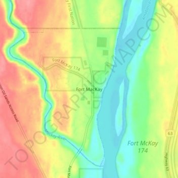
Naam: Topografische kaart Fort MacKay, hoogte, reliëf.
Locatie: Fort MacKay, Wood Buffalo, Alberta, T0P 1C0, Canada (57.16257 -111.65784 57.20257 -111.61784)
Gemiddelde hoogte: 265 m
Minimale hoogte: 228 m
Maximale hoogte: 306 m
Fort McKay (/məˈkaɪ/ mə-KY) or Fort MacKay is a community in northeast Alberta, Canada that is located at the confluence of the Athabasca and MacKay rivers. It is approximately 54 km (34 mi) north of Fort McMurray via Highway 63 and Fort McKay Road. The community has an elevation of 260 m (850 ft).