
Topografische kaart Lac à la Pêche
Interactieve kaart
Klik op de kaart om de hoogte weer te geven.
Over deze kaart
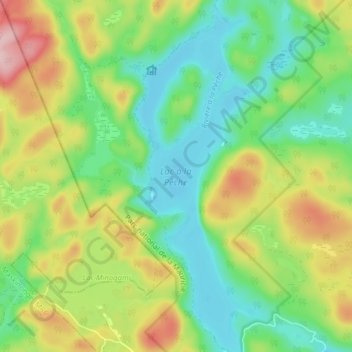
Naam: Topografische kaart Lac à la Pêche, hoogte, reliëf.
Locatie: Lac à la Pêche, Shawinigan, Mauricie, Quebec, Canada (46.65252 -72.86800 46.70658 -72.84256)
Gemiddelde hoogte: 244 m
Minimale hoogte: 170 m
Maximale hoogte: 372 m
Andere topografische kaarten
Klik op een kaart om zijn topografie, zijn hoogte en zijn reliëf te bekijken.
La Mauricie National Park
Canada > Quebec > Shawinigan
La Mauricie National Park, Shawinigan, Mauricie, Quebec, Canada
Gemiddelde hoogte: 384 m