
Doe een donatie
Rust jezelf uit voor je volgende avontuur:
Als Amazon-partner verdient deze site een commissie op in aanmerking komende aankopen, zonder extra kosten voor jou.
Topografische kaart lac Seul
Klik op de kaart om de hoogte weer te geven.
Doe een donatie
Rust jezelf uit voor je volgende avontuur:
Als Amazon-partner verdient deze site een commissie op in aanmerking komende aankopen, zonder extra kosten voor jou.
lac Seul
Lac Seul is a large, crescent shaped reservoir in Kenora District, northwestern Ontario, Canada. It is approximately 241 km (150 mi) long. It has a maximum (regulated) depth of 47.2 m, with a surface elevation of 357 m above sea level. Its level is raised in the summer and then drawn down in the winter months to reach points of as low as 16 feet below the maximum level. It is the second largest body of water entirely within the province of Ontario (Lake Nipigon being first). The lake consists of open water bays, narrow channels, and islands. It is a relatively shallow lake with many rock shoals. This provides a good habitat for walleye (also known as "yellow pickerel") and northern pike as well as yellow perch. During the Lac Seul project of 1968-1972 no muskelunge were noted in the catches of research nets set over those years. Significant numbers of whitefish, tullibee, burbot and cisco were noted as well although they infrequently were noted in the sport fishery. Lac Seul is noted for offering some of the best fishing in Ontario.
Doe een donatie
Rust jezelf uit voor je volgende avontuur:
Als Amazon-partner verdient deze site een commissie op in aanmerking komende aankopen, zonder extra kosten voor jou.
Over deze kaart
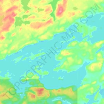
Naam: Topografische kaart lac Seul, hoogte, reliëf.
Gemiddelde hoogte: 374 m
Minimale hoogte: 351 m
Maximale hoogte: 431 m
Doe een donatie
Rust jezelf uit voor je volgende avontuur:
Als Amazon-partner verdient deze site een commissie op in aanmerking komende aankopen, zonder extra kosten voor jou.
Andere topografische kaarten
Klik op een kaart om zijn topografie, zijn hoogte en zijn reliëf te bekijken.
Hudson Bay Lowlands
Canada > Ontario > Kenora District > Unorganized Kenora District
Gemiddelde hoogte: 17 m
Burditt Lake
Canada > Ontario > Kenora District > Unorganized Kenora District
Gemiddelde hoogte: 367 m
Doe een donatie
Rust jezelf uit voor je volgende avontuur:
Als Amazon-partner verdient deze site een commissie op in aanmerking komende aankopen, zonder extra kosten voor jou.
Cardinal (Lac) Lake
Canada > Ontario > Kenora District > Unorganized Kenora District
Gemiddelde hoogte: 392 m
Carroll Lake
Canada > Ontario > Kenora District > Unorganized Kenora District
Gemiddelde hoogte: 338 m
Doe een donatie
Rust jezelf uit voor je volgende avontuur:
Als Amazon-partner verdient deze site een commissie op in aanmerking komende aankopen, zonder extra kosten voor jou.
Granite Lake
Canada > Ontario > Kenora District > Unorganized Kenora District
Gemiddelde hoogte: 355 m
Doe een donatie
Rust jezelf uit voor je volgende avontuur:
Als Amazon-partner verdient deze site een commissie op in aanmerking komende aankopen, zonder extra kosten voor jou.
Gordon Island
Canada > Ontario > Kenora District > Unorganized Kenora District
Gemiddelde hoogte: 349 m
Doe een donatie
Rust jezelf uit voor je volgende avontuur:
Als Amazon-partner verdient deze site een commissie op in aanmerking komende aankopen, zonder extra kosten voor jou.
Grindstone Lake
Canada > Ontario > Kenora District > Unorganized Kenora District
Gemiddelde hoogte: 371 m
Doe een donatie
Rust jezelf uit voor je volgende avontuur:
Als Amazon-partner verdient deze site een commissie op in aanmerking komende aankopen, zonder extra kosten voor jou.
Warwick Lake
Canada > Ontario > Kenora District > Unorganized Kenora District
Gemiddelde hoogte: 341 m
Slate Islands
Canada > Ontario > Kenora District > Unorganized Kenora District
Gemiddelde hoogte: 322 m
Doe een donatie
Rust jezelf uit voor je volgende avontuur:
Als Amazon-partner verdient deze site een commissie op in aanmerking komende aankopen, zonder extra kosten voor jou.
Mackey Island
Canada > Ontario > Kenora District > Unorganized Kenora District
Gemiddelde hoogte: 336 m
Big Island Lake
Canada > Ontario > Kenora District > Unorganized Kenora District
Gemiddelde hoogte: 430 m
Doe een donatie
Rust jezelf uit voor je volgende avontuur:
Als Amazon-partner verdient deze site een commissie op in aanmerking komende aankopen, zonder extra kosten voor jou.
Nine Mile Lake
Canada > Ontario > Kenora District > Unorganized Kenora District
Gemiddelde hoogte: 413 m
Doe een donatie
Rust jezelf uit voor je volgende avontuur:
Als Amazon-partner verdient deze site een commissie op in aanmerking komende aankopen, zonder extra kosten voor jou.
Chisholm Island
Canada > Ontario > Kenora District > Unorganized Kenora District
Gemiddelde hoogte: 323 m
Clearwater Bay
Canada > Ontario > Kenora District > Unorganized Kenora District
Gemiddelde hoogte: 334 m
Doe een donatie
Rust jezelf uit voor je volgende avontuur:
Als Amazon-partner verdient deze site een commissie op in aanmerking komende aankopen, zonder extra kosten voor jou.
Muskeg River
Canada > Ontario > Kenora District > Unorganized Kenora District
Gemiddelde hoogte: 357 m
Muskeg River
Canada > Ontario > Kenora District > Unorganized Kenora District
Gemiddelde hoogte: 363 m
Dingwall Island
Canada > Ontario > Kenora District > Unorganized Kenora District
Gemiddelde hoogte: 325 m
Doe een donatie
Rust jezelf uit voor je volgende avontuur:
Als Amazon-partner verdient deze site een commissie op in aanmerking komende aankopen, zonder extra kosten voor jou.
Little Boulder Lake
Canada > Ontario > Kenora District > Unorganized Kenora District
Gemiddelde hoogte: 359 m
Cameron Island
Canada > Ontario > Kenora District > Unorganized Kenora District
Gemiddelde hoogte: 338 m
Doe een donatie
Rust jezelf uit voor je volgende avontuur:
Als Amazon-partner verdient deze site een commissie op in aanmerking komende aankopen, zonder extra kosten voor jou.