
Doe een donatie
Rust jezelf uit voor je volgende avontuur:
Als Amazon-partner verdient deze site een commissie op in aanmerking komende aankopen, zonder extra kosten voor jou.
Topografische kaart Bradgate Park
Klik op de kaart om de hoogte weer te geven.
Doe een donatie
Rust jezelf uit voor je volgende avontuur:
Als Amazon-partner verdient deze site een commissie op in aanmerking komende aankopen, zonder extra kosten voor jou.
Bradgate Park
Overlying the Beacon Hill Formation, but found a little further down the hillside to the south, are the Bradgate Formation beds, the most notable of which is the Sliding Stone Slump Breccia rocks. Forming a line of crags below Old John, these are laminated mudstones, with layers of sandstone, mainly of volcanic origin. The beds are substantially warped, contorted and folded. Many of the more intricate folds and 'sag' patterns are thought to have occurred while the sediments were unconsolidated and water saturated. Suggested causes for these include slumping, earth tremors and fault-movements, trapped water or gases and volcanic bomb impacts. Outcrops of other rocks of the Bradgate Formation are found further down the slope. These are younger than and stratigraphically above the breccia, but the uplift from ancient mountain-building, the dip of the beds and erosion of overlying rocks mean that the younger rocks are encountered at progressively lower altitudes.
Doe een donatie
Rust jezelf uit voor je volgende avontuur:
Als Amazon-partner verdient deze site een commissie op in aanmerking komende aankopen, zonder extra kosten voor jou.
Over deze kaart
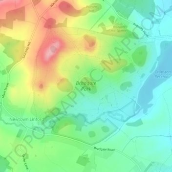
Naam: Topografische kaart Bradgate Park, hoogte, reliëf.
Gemiddelde hoogte: 126 m
Minimale hoogte: 77 m
Maximale hoogte: 209 m
Doe een donatie
Rust jezelf uit voor je volgende avontuur:
Als Amazon-partner verdient deze site een commissie op in aanmerking komende aankopen, zonder extra kosten voor jou.
Andere topografische kaarten
Klik op een kaart om zijn topografie, zijn hoogte en zijn reliëf te bekijken.
Old John
United Kingdom > England > Leicestershire > Charnwood > Newtown Linford
Gemiddelde hoogte: 143 m