
Doe een donatie
Rust jezelf uit voor je volgende avontuur:
Als Amazon-partner verdient deze site een commissie op in aanmerking komende aankopen, zonder extra kosten voor jou.
Topografische kaart Byron
Klik op de kaart om de hoogte weer te geven.
Doe een donatie
Rust jezelf uit voor je volgende avontuur:
Als Amazon-partner verdient deze site een commissie op in aanmerking komende aankopen, zonder extra kosten voor jou.
Byron
Byron is located in Byron Township at the junction of Illinois Route 72 and Illinois Route 2. Byron's topography includes a man-made prairie and the Rock River that passes through the town. It is generally flat and is ideal for farming in most regions. According to the 2010 census, Byron has a total area of 3.572 square miles (9.25 km2), of which 3.57 square miles (9.25 km2) (or 99.94%) is land and 0.002 square miles (0.01 km2) (or 0.06%) is water.
Doe een donatie
Rust jezelf uit voor je volgende avontuur:
Als Amazon-partner verdient deze site een commissie op in aanmerking komende aankopen, zonder extra kosten voor jou.
Over deze kaart
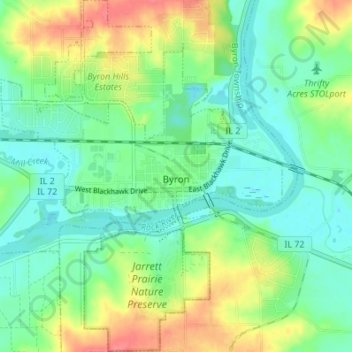
Naam: Topografische kaart Byron, hoogte, reliëf.
Gemiddelde hoogte: 226 m
Minimale hoogte: 204 m
Maximale hoogte: 267 m
Doe een donatie
Rust jezelf uit voor je volgende avontuur:
Als Amazon-partner verdient deze site een commissie op in aanmerking komende aankopen, zonder extra kosten voor jou.
Andere topografische kaarten
Klik op een kaart om zijn topografie, zijn hoogte en zijn reliëf te bekijken.