
Topografische kaart Limbach
Interactieve kaart
Klik op de kaart om de hoogte weer te geven.
Over deze kaart
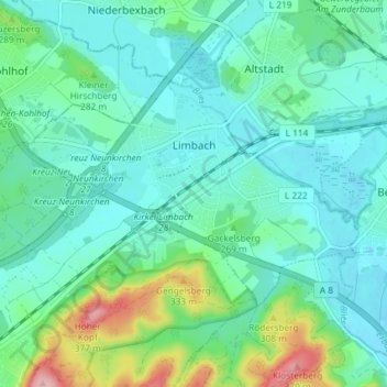
Naam: Topografische kaart Limbach, hoogte, reliëf.
Locatie: Limbach, Kirkel, Saarpfalz-Kreis, Saarland, 66459, Deutschland (49.29441 7.23247 49.32300 7.30548)
Gemiddelde hoogte: 256 m
Minimale hoogte: 221 m
Maximale hoogte: 384 m
Andere topografische kaarten
Klik op een kaart om zijn topografie, zijn hoogte en zijn reliëf te bekijken.
66459
Deutschland > Saarland > Saarpfalz-Kreis > Kirkel
66459, Limbach, Kirkel, Saarpfalz-Kreis, Saarland, Deutschland
Gemiddelde hoogte: 267 m
Hirschberg
Deutschland > Saarland > Saarpfalz-Kreis > Kirkel
Hirschberg, Kirkel, Saarpfalz-Kreis, Saarland, 66459, Deutschland
Gemiddelde hoogte: 293 m