
Topografische kaart Linwood
Interactieve kaart
Klik op de kaart om de hoogte weer te geven.
Over deze kaart
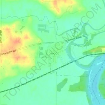
Naam: Topografische kaart Linwood, hoogte, reliëf.
Locatie: Linwood, Leavenworth County, Kansas, United States (38.99529 -95.04396 39.00772 -95.02280)
Gemiddelde hoogte: 248 m
Minimale hoogte: 233 m
Maximale hoogte: 275 m
Andere topografische kaarten
Klik op een kaart om zijn topografie, zijn hoogte en zijn reliëf te bekijken.
Leavenworth
United States > Kansas > Leavenworth County > Leavenworth
Leavenworth, Leavenworth County, Kansas, 66048, United States
Gemiddelde hoogte: 277 m