
Topografische kaart Gołdap
Interactieve kaart
Klik op de kaart om de hoogte weer te geven.
Over deze kaart
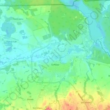
Naam: Topografische kaart Gołdap, hoogte, reliëf.
Gemiddelde hoogte: 167 m
Minimale hoogte: 141 m
Maximale hoogte: 241 m
Andere topografische kaarten
Klik op een kaart om zijn topografie, zijn hoogte en zijn reliëf te bekijken.
Rapa
Poland > Warmian-Masurian Voivodeship > Gołdap County
Rapa, gmina Banie Mazurskie, Gołdap County, Warmian-Masurian Voivodeship, 19-520, Poland
Gemiddelde hoogte: 101 m
Degucie
Poland > Warmian-Masurian Voivodeship > Gołdap County > Degucie
Degucie, gmina Dubeninki, Gołdap County, Warmian-Masurian Voivodeship, Poland
Gemiddelde hoogte: 237 m