
Topografische kaart San Blas
Interactieve kaart
Klik op de kaart om de hoogte weer te geven.
Over deze kaart
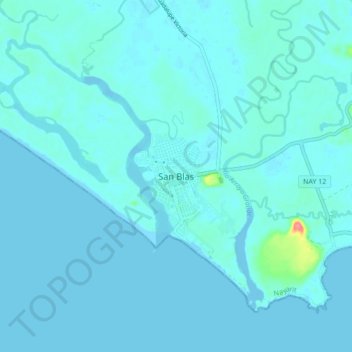
Naam: Topografische kaart San Blas, hoogte, reliëf.
Locatie: San Blas, Nayarit, 63774, México (21.50294 -105.32490 21.58294 -105.24490)
Gemiddelde hoogte: 5 m
Minimale hoogte: -4 m
Maximale hoogte: 72 m
Andere topografische kaarten
Klik op een kaart om zijn topografie, zijn hoogte en zijn reliëf te bekijken.
Jalcocotán
Jalcocotán, San Blas, Nayarit, 63770, México
Gemiddelde hoogte: 534 m
Islas Marías
Islas Marías, San Blas, Nayarit, México
Gemiddelde hoogte: 14 m