
Topografische kaart Tunkwa Lake
Interactieve kaart
Klik op de kaart om de hoogte weer te geven.
Over deze kaart
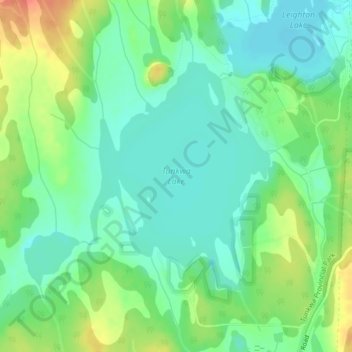
Naam: Topografische kaart Tunkwa Lake, hoogte, reliëf.
Gemiddelde hoogte: 1.161 m
Minimale hoogte: 1.143 m
Maximale hoogte: 1.195 m
Andere topografische kaarten
Klik op een kaart om zijn topografie, zijn hoogte en zijn reliëf te bekijken.
Williams Creek
Canada > British Columbia > Thompson-Nicola Regional District > Area J (Copper Desert Country)
Williams Creek, Area J (Copper Desert Country), Thompson-Nicola Regional District, British Columbia, Canada
Gemiddelde hoogte: 1.100 m
Fraser Plateau
Canada > British Columbia > Thompson-Nicola Regional District > Area J (Copper Desert Country)
Fraser Plateau, Area J (Copper Desert Country), Thompson-Nicola Regional District, British Columbia, Canada
Gemiddelde hoogte: 1.800 m
Gisborne Lake
Canada > British Columbia > Thompson-Nicola Regional District > Area J (Copper Desert Country)
Gisborne Lake, Area J (Copper Desert Country), Thompson-Nicola Regional District, British Columbia, Canada
Gemiddelde hoogte: 1.321 m