
Topografische kaart gmina Włodawa
Interactieve kaart
Klik op de kaart om de hoogte weer te geven.
Over deze kaart
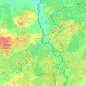
Naam: Topografische kaart gmina Włodawa, hoogte, reliëf.
Locatie: gmina Włodawa, Włodawa County, Lublin Voivodeship, Poland (51.38789 23.35489 51.67485 23.68641)
Gemiddelde hoogte: 166 m
Minimale hoogte: 148 m
Maximale hoogte: 200 m
Andere topografische kaarten
Klik op een kaart om zijn topografie, zijn hoogte en zijn reliëf te bekijken.
Huta
Poland > Lublin Voivodeship > Włodawa County > Dubeczno
Huta, Dubeczno, gmina Hańsk, Włodawa County, Lublin Voivodeship, 22-235, Poland
Gemiddelde hoogte: 169 m