
Topografische kaart Polatlı
Interactieve kaart
Klik op de kaart om de hoogte weer te geven.
Over deze kaart
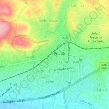
Naam: Topografische kaart Polatlı, hoogte, reliëf.
Gemiddelde hoogte: 889 m
Minimale hoogte: 833 m
Maximale hoogte: 988 m
Polatlı (formerly Ancient Greek: Γόρδιον, Górdion and Latin: Gordium) is a city and a district in Ankara Province in the Central Anatolia region of Turkey, 80 km west of the Turkish capital Ankara, on the road to Eskişehir. According to 2019 census, population of the district is 125,075 of which 98,605 live in the city of Polatlı. The district covers an area of 3,789 km2, and the average elevation is 850 m.
Andere topografische kaarten
Klik op een kaart om zijn topografie, zijn hoogte en zijn reliëf te bekijken.
Karacaahmet
Karacaahmet, Polatlı, Ankara, Central Anatolia Region, Turkey
Gemiddelde hoogte: 683 m
Yassıhüyük
Yassıhüyük, Polatlı, Ankara, Central Anatolia Region, Turkey
Gemiddelde hoogte: 698 m