
Topografische kaart Kalaw
Interactieve kaart
Klik op de kaart om de hoogte weer te geven.
Over deze kaart
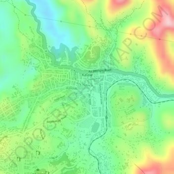
Naam: Topografische kaart Kalaw, hoogte, reliëf.
Gemiddelde hoogte: 1.348 m
Minimale hoogte: 1.249 m
Maximale hoogte: 1.498 m
The hill station is located at an elevation of 1310 metres, 50 km from the Inle lake. Kalaw is famous for hiking and trekking. Many trekking trails ranging from nearby places to Inle Lake and Pindaya. The town still feels like a high-altitude holiday resort – the air is cool, the atmosphere is calm and the tree-lined streets still contain a smattering of colonial-era architecture – while the surrounding hills are fine for relatively easy day or overnight treks to Danu, Danaw, Palaung, Pa-O and Taung Yo villages.