
Topografische kaart Ziemsko
Interactieve kaart
Klik op de kaart om de hoogte weer te geven.
Over deze kaart
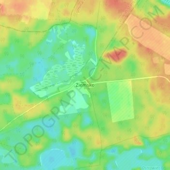
Naam: Topografische kaart Ziemsko, hoogte, reliëf.
Gemiddelde hoogte: 112 m
Minimale hoogte: 93 m
Maximale hoogte: 134 m
Andere topografische kaarten
Klik op een kaart om zijn topografie, zijn hoogte en zijn reliëf te bekijken.
Kalisz Pomorski
Poland > West Pomeranian Voivodeship > Drawsko County
Kalisz Pomorski, gmina Kalisz Pomorski, Drawsko County, West Pomeranian Voivodeship, 78-540, Poland
Gemiddelde hoogte: 110 m
Czaplinek
Poland > West Pomeranian Voivodeship > Drawsko County
Czaplinek, gmina Czaplinek, Drawsko County, West Pomeranian Voivodeship, 78-550, Poland
Gemiddelde hoogte: 145 m
Drawsko
Poland > West Pomeranian Voivodeship > Drawsko County > Czaplinek
Drawsko, Czaplinek, gmina Czaplinek, Drawsko County, West Pomeranian Voivodeship, Poland
Gemiddelde hoogte: 143 m