
Topografische kaart Bayard
Interactieve kaart
Klik op de kaart om de hoogte weer te geven.
Over deze kaart
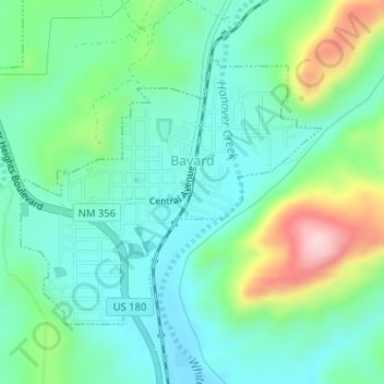
Naam: Topografische kaart Bayard, hoogte, reliëf.
Locatie: Bayard, Grant County, New Mexico, 88023, United States (32.75026 -108.14493 32.76880 -108.11978)
Gemiddelde hoogte: 1.816 m
Minimale hoogte: 1.746 m
Maximale hoogte: 2.003 m
Bayard is located in the southern foothills of the Pinos Altos Range and Mogollon Mountains in the southwestern portion of New Mexico and situated east of the Continental Divide at an elevation of approximately 5,800 feet (1,800 m). Gila National Forest lies north from here. A semi-arid desert of predominantly grasses and yucca is in Bayard's southern portion.
Andere topografische kaarten
Klik op een kaart om zijn topografie, zijn hoogte en zijn reliëf te bekijken.
Silver City
United States > New Mexico > Grant County
Silver City, Grant County, New Mexico, 88062, United States
Gemiddelde hoogte: 1.850 m
Hurley
United States > New Mexico > Grant County
Hurley, Grant County, New Mexico, United States
Gemiddelde hoogte: 1.734 m
Arenas Valley
United States > New Mexico > Grant County > Silver City
Arenas Valley, Silver City, Grant County, New Mexico, 88022, United States
Gemiddelde hoogte: 1.873 m
Santa Clara
United States > New Mexico > Grant County
Santa Clara, Grant County, New Mexico, 88026, United States
Gemiddelde hoogte: 1.833 m
Mallet Pond
United States > New Mexico > Grant County
Mallet Pond, Grant County, New Mexico, United States
Gemiddelde hoogte: 1.802 m
Dwyer
United States > New Mexico > Grant County
Dwyer, Grant County, New Mexico, 88034, United States
Gemiddelde hoogte: 1.616 m
Pinos Altos
United States > New Mexico > Grant County
Pinos Altos, Grant County, New Mexico, 88053, United States
Gemiddelde hoogte: 2.142 m
Aldo Leopold Wilderness
United States > New Mexico > Grant County
Aldo Leopold Wilderness, Grant County, New Mexico, United States
Gemiddelde hoogte: 2.249 m