Geolokaliseren

Topografische kaart Cibolo

Interactieve kaart

Klik op de kaart om de hoogte weer te geven.

Over deze kaart

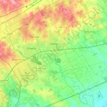
Naam: Topografische kaart Cibolo, hoogte, reliëf.

Locatie: Cibolo, Guadalupe County, Texas, 78108, United States (29.49503 -98.27420 29.61847 -98.09733)

Gemiddelde hoogte: 220 m

Minimale hoogte: 172 m

Maximale hoogte: 291 m

Andere topografische kaarten

Klik op een kaart om zijn topografie, zijn hoogte en zijn reliëf te bekijken.

Seguin

United States > Texas > Guadalupe County

Seguin, Guadalupe County, Texas, United States

Gemiddelde hoogte: 172 m

Schertz

United States > Texas > Guadalupe County

Schertz, Guadalupe County, Texas, 78154, United States

Gemiddelde hoogte: 232 m

Zorn

United States > Texas > Guadalupe County

Zorn, Guadalupe County, Texas, United States

Gemiddelde hoogte: 169 m

Kingsbury

United States > Texas > Guadalupe County

Kingsbury, Guadalupe County, Texas, United States

Gemiddelde hoogte: 166 m