
Topografische kaart Ostrów Mazowiecka
Interactieve kaart
Klik op de kaart om de hoogte weer te geven.
Over deze kaart
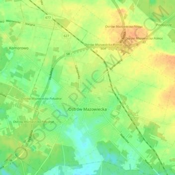
Naam: Topografische kaart Ostrów Mazowiecka, hoogte, reliëf.
Gemiddelde hoogte: 129 m
Minimale hoogte: 111 m
Maximale hoogte: 147 m
Andere topografische kaarten
Klik op een kaart om zijn topografie, zijn hoogte en zijn reliëf te bekijken.
Kiełczew
Poland > Masovian Voivodeship > Ostrów Mazowiecka County
Kiełczew, gmina Małkinia Górna, Ostrów Mazowiecka County, Masovian Voivodeship, Poland
Gemiddelde hoogte: 99 m
Małkinia Górna
Poland > Masovian Voivodeship > Ostrów Mazowiecka County
Małkinia Górna, gmina Małkinia Górna, Ostrów Mazowiecka County, Masovian Voivodeship, Poland
Gemiddelde hoogte: 104 m