
Topografische kaart Levita
Interactieve kaart
Klik op de kaart om de hoogte weer te geven.
Over deze kaart
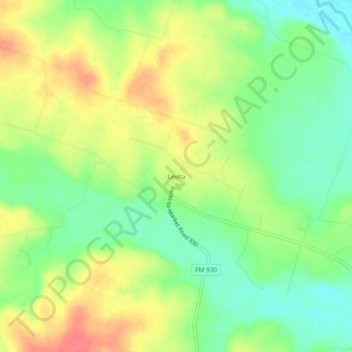
Naam: Topografische kaart Levita, hoogte, reliëf.
Locatie: Levita, Coryell County, Texas, United States (31.49488 -97.90808 31.53488 -97.86808)
Gemiddelde hoogte: 276 m
Minimale hoogte: 247 m
Maximale hoogte: 309 m
Andere topografische kaarten
Klik op een kaart om zijn topografie, zijn hoogte en zijn reliëf te bekijken.
Jonesboro
United States > Texas > Coryell County
Jonesboro, Coryell County, Texas, United States
Gemiddelde hoogte: 284 m
Hurst Springs
United States > Texas > Coryell County
Hurst Springs, Coryell County, Texas, United States
Gemiddelde hoogte: 308 m
Ireland
United States > Texas > Coryell County
Ireland, Coryell County, Texas, United States
Gemiddelde hoogte: 315 m
South Mountain
United States > Texas > Coryell County
South Mountain, Coryell County, Texas, United States
Gemiddelde hoogte: 306 m
Oglesby
United States > Texas > Coryell County
Oglesby, Coryell County, Texas, United States
Gemiddelde hoogte: 257 m
Flat
United States > Texas > Coryell County
Flat, Coryell County, Texas, 76526, United States
Gemiddelde hoogte: 266 m
Mound
United States > Texas > Coryell County
Mound, Coryell County, Texas, 76558, United States
Gemiddelde hoogte: 222 m
Pidcoke
United States > Texas > Coryell County
Pidcoke, Coryell County, Texas, United States
Gemiddelde hoogte: 264 m
Gatesville
United States > Texas > Coryell County
Gatesville, Coryell County, Texas, United States
Gemiddelde hoogte: 261 m
Copperas Cove
United States > Texas > Coryell County
Copperas Cove, Coryell County, Texas, 76522, United States
Gemiddelde hoogte: 317 m
Pancake
United States > Texas > Coryell County
Pancake, Coryell County, Texas, United States
Gemiddelde hoogte: 358 m
Evant
United States > Texas > Coryell County
Evant, Coryell County, Texas, United States
Gemiddelde hoogte: 382 m
Purmela
United States > Texas > Coryell County
Purmela, Coryell County, Texas, 76566, United States
Gemiddelde hoogte: 321 m