
Topografische kaart Sistema Ibérico
Interactieve kaart
Klik op de kaart om de hoogte weer te geven.
Sistema Ibérico
The geology of the Iberian System is complex, for it can hardly be defined as a homogeneous system. It is composed of a haphazard and motley series of mountain ranges, massifs, plateaus and depressions without a definite common petrologic composition and overall structure. Nummulite limestone, marble and sandstone are common throughout the area. Some of the parts of the system stand geologically isolated, interrupting the continuity of the whole, linked to the other parts through high plateaus of varying altitudes.
Over deze kaart
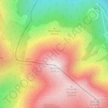
Naam: Topografische kaart Sistema Ibérico, hoogte, reliëf.
Gemiddelde hoogte: 1.906 m
Minimale hoogte: 1.413 m
Maximale hoogte: 2.313 m