
Topografische kaart Mosina
Interactieve kaart
Klik op de kaart om de hoogte weer te geven.
Over deze kaart
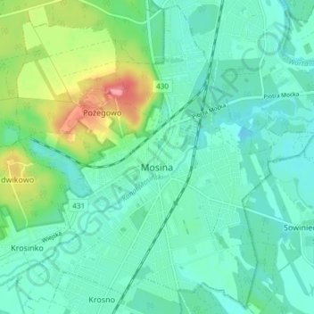
Naam: Topografische kaart Mosina, hoogte, reliëf.
Gemiddelde hoogte: 71 m
Minimale hoogte: 51 m
Maximale hoogte: 134 m
Andere topografische kaarten
Klik op een kaart om zijn topografie, zijn hoogte en zijn reliëf te bekijken.
Poznań
Poland > Greater Poland Voivodeship > Poznań County
Poznań, Poznań County, Greater Poland Voivodeship, Poland
Gemiddelde hoogte: 85 m
Stęszew
Poland > Greater Poland Voivodeship > Poznań County
Stęszew, gmina Stęszew, Poznań County, Greater Poland Voivodeship, Poland
Gemiddelde hoogte: 76 m
Będlewo
Poland > Greater Poland Voivodeship > Poznań County
Będlewo, gmina Stęszew, Poznań County, Greater Poland Voivodeship, Poland
Gemiddelde hoogte: 73 m
Komorniki
Poland > Greater Poland Voivodeship > Poznań County
Komorniki, gmina Komorniki, Poznań County, Greater Poland Voivodeship, 62-052, Poland
Gemiddelde hoogte: 84 m
Wiry
Poland > Greater Poland Voivodeship > Poznań County
Wiry, gmina Komorniki, Poznań County, Greater Poland Voivodeship, 62-051, Poland
Gemiddelde hoogte: 81 m
Poznań
Poland > Greater Poland Voivodeship > Poznań County
Poznań, Poznań County, Greater Poland Voivodeship, Poland
Gemiddelde hoogte: 85 m
Trzebaw
Poland > Greater Poland Voivodeship > Poznań County
Trzebaw, gmina Stęszew, Poznań County, Greater Poland Voivodeship, Poland
Gemiddelde hoogte: 79 m
Buk
Poland > Greater Poland Voivodeship > Poznań County > Buk
Buk, gmina Buk, Poznań County, Greater Poland Voivodeship, Poland
Gemiddelde hoogte: 86 m
Swarzędz
Poland > Greater Poland Voivodeship > Poznań County > Swarzędz
Swarzędz, gmina Swarzędz, Poznań County, Greater Poland Voivodeship, 62-020, Poland
Gemiddelde hoogte: 87 m
Luboń
Poland > Greater Poland Voivodeship > Poznań County > Luboń
Luboń, Poznań County, Greater Poland Voivodeship, Poland
Gemiddelde hoogte: 74 m
Przeźmierowo
Poland > Greater Poland Voivodeship > Poznań County > Przeźmierowo
Przeźmierowo, gmina Tarnowo Podgórne, Poznań County, Greater Poland Voivodeship, 62-081, Poland
Gemiddelde hoogte: 91 m