
Topografische kaart Dormer Mountain
Interactieve kaart
Klik op de kaart om de hoogte weer te geven.
Over deze kaart
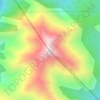
Naam: Topografische kaart Dormer Mountain, hoogte, reliëf.
Gemiddelde hoogte: 2.243 m
Minimale hoogte: 1.810 m
Maximale hoogte: 2.756 m
Andere topografische kaarten
Klik op een kaart om zijn topografie, zijn hoogte en zijn reliëf te bekijken.
Kananaskis
Canada > Alberta > Municipal District of Bighorn > Kananaskis
Kananaskis, Municipal District of Bighorn, Alberta, T0L 2C0, Canada
Gemiddelde hoogte: 1.426 m
Gap Lake
Canada > Alberta > Municipal District of Bighorn
Gap Lake, Municipal District of Bighorn, Alberta, Canada
Gemiddelde hoogte: 1.424 m
Waiparous
Canada > Alberta > Municipal District of Bighorn
Waiparous, Municipal District of Bighorn, Alberta, Canada
Gemiddelde hoogte: 1.338 m
Exshaw
Canada > Alberta > Municipal District of Bighorn
Exshaw, Municipal District of Bighorn, Alberta, T0L 2C0, Canada
Gemiddelde hoogte: 1.420 m
South Ghost Peak
Canada > Alberta > Municipal District of Bighorn
South Ghost Peak, Municipal District of Bighorn, Alberta, Canada
Gemiddelde hoogte: 2.240 m